Digital project grant funds open-access map creation of Shakespearean London


Professor Highley’s project creates map overlays to provide viewers a more comprehensive view of what Shakespearean London looked like, compared to different eras in the modern city.
Imagine you are walking through the streets of London during the Renaissance era. You enter a nearby theater and experience one of Shakespeare’s plays – maybe even the world premiere of “Hamlet” or “Romeo and Juliet” – before a night on the town.
Ohio State Professor Chris Highley is working toward recreating just that experience thanks to a recent grant awarded to him and a team of researchers working on "Shakespeare’s Theaterscape: Mapping London's Theater Districts, 1576-1642."
Highley, who joined the English faculty at Ohio State in 1991, said that the project aims to create an “interactive geographic information system (GIS) map that would allow us to recreate these theater districts or neighborhoods in unprecedented detail.”
“Our model is going to be unique in terms of the level of detail we provide,” Highley added. “We really drill down into street level. So, in part the money is being used to pay a GIS expert to create the website and the digital maps.”
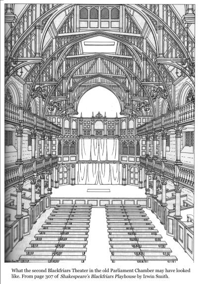
When building these maps, there are four specific districts that Highley and his fellow researchers are focused on: the Blackfriars district in the south-west corner of the City of London, the Fortune District to the north of the city, the Curtain District around Shoreditch, and the Cockpit in St. Giles in the Fields to the west. Highley, who is tasked with focusing on the Blackfriars District, said these four areas, along with the bankside area of Shakespeare’s famous Globe Theatre, stand out for their cultural significance.
At this stage, the team’s research, however, is not so much focused on the on-stage performances, but rather on the socioeconomic impact of the theaters in the area. The experience of what it was like inside a theater during a performance of a play has already garnered a lot of critical attention, he said: “our task is to recreate the built environment and ecosystem through which playgoers passed on their way to and from that performance.”
“We want to have a better sense of how theaters were seen within their local communities and how they functioned,” Highley said. “And we want to see how these connections, both cultural and economic, created a very rich, nuanced sense of the theater's context and its physical place within the City of London.”
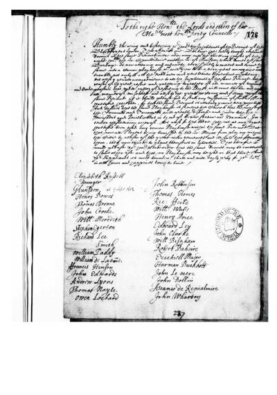
To populate these maps, Highley and a group of fellow scholars and researchers have and will spend years compiling data and information from various sources. The grant also helped fund a recent trip to London, where Highley and his team visited “some of the key archives that contain primary documents” that are essential for them to build the maps.
Locations that Highley visited include the London Archives, which hold things like parish registers and the wills of people who lived in these districts and left money to these parishes. Also included in his research is the Museum of London’s archeological division.
“There's important archaeology to take into consideration here,” Highley said. “There are physical remains that we can look at, both on site and in terms of relics and artifacts that have survived and are now in collections.” Examples of these artifacts include clay pipes, glazed pottery, and tokens that were used instead of coins. Highley and his fellow researchers are not only trying to include physical locations but also add information about the people who populated the area and how they directly impacted the theater landscape in 17thCentury London.
“What we're trying to do is add depth and detail to what we know existed in the late 16th and 17th centuries,” he said. “So, to add further lanes, passageways, courtyards, and then even the footprints of buildings, including the theaters, obviously, that we know existed from different original sources that we're looking at. Once the maps are complete, when you click on a location that's been identified and is part of the underlying database, it will bring up information about that place, including important events that occurred there, important people related to that place like residents or leaseholders or owners of the property.”
A prototype of the project is set to debut at the Shakespeare Association of America Conference in April 2025. While a completed GIS map is the current goal, Highley has higher aspirations for the project, should more funding come their way.
“I do have a kind of a dream of being able to create three-dimensional virtual reality walkthroughs,” Highley said. “Eventually, given enough funding, given the technology, developing some sort of a virtual reality, three-dimensional recreation, maybe what it was like making the walk, even from the church to the theater and back again. We could potentially recreate something like that.”
Ultimately, Highley said this project is meant not only to appeal to scholars, but to be available to anyone interested in Shakespearean London.
“There's all kinds of ways in which this could be a great pedagogical tool, engaging students as active contributors in developing the maps even further.”
Learn more about Dr. Highley's work on Exploring Shakespeare’s London with Christopher Highley from the Voices of Excellence podcast.